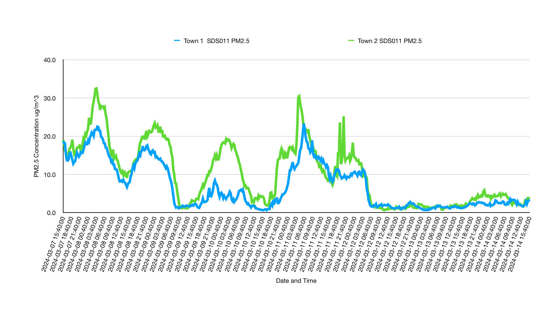
I was wondering if anyone has looked into how their sensor data compares with other sensors in their area. I have been looking at the PM 2.5 profiles from sensors placed around 30 miles apart and they look quite similar. I can think of only two reasons why this would be the case
Local sources play little part in the PM 2.5 concentration
Weather dominates the profile.
Has anyone else investigated this?
There are not much sensors around here (north italy), but i see some corelation with goverment measurements and there is a difference between rural areas and city’s.
I think it may depends on the location, if there is a lot of industry or if people are heating with wood then the PM 2.5 will likely be higher.
I also observed peeks in PM 2.5 in the winter when citizens started heating with with wood.
As far i know, only humidity is influencing the Nova PM sensor measurements.
For having used various sensors in two different towns during a couple of years, I can say that the altitude of your measurements has quite a strong influence.
Here in Paris the difference between ground level and 4th floor is more than twofold for instance, for PM2.5 and PM10 measurements…
I encourage filling the ‘altitude’ field as accurately as possible when setting the sensor to publish
many thanks. I have indeed checked the altitude of both locations and they are different. My point is the data is not as significantly different as I was anticipating and appears to be at odds with what you find.
HIS link (from @jakasspeech3 ) is a shop, because he is a spammer.
He posts in the forum for the fist time, writes a standard sentence that can relate to anything ('thanks for sharing…') and adds HIS advertisment within my text, so (like me) you click on it…
This was called ‘spam comment’ years ago alredy, at the time of ascii forums…
Worst of all, I don’t know how to declare it as such, the only ‘person’ we can address this seems to be Mr. @discobot , of which reaction I’m a bit skeptical…
I just hope he didn’t do this in 100 other threads…
H.
We evaluated whether using county-level data to characterize public health measures in cities biases the characteri zation of city populations.this new method, called the Degree Spacebar clicker of Urbanisation, classifies the entire territory of a country into three classes We’ve recently acquired an extensive dataset from OpenStreetMap, packed with information about cities, towns, villages, and hamlets from all around the globe.
I was wondering if anyone has looked into how their sensor data compares with other sensors in their area. human benchmark I have been looking at the The OECD Local Data Portal lets you visualise and compare municipal and local data across 41 countries. … Comparing cities across countries requires …